bobspirko.ca | Home | Canada Trips | US Trips | Hiking | Snowshoeing | MAP | About
![]()
Manly Beacon
via Gower Gulch and Golden Canyon
Death Valley, California
April 11, 2016
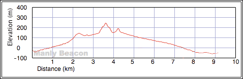
Distance: 9.2 km (5.7 mi)
Cumulative Elevation Gain: 369 m (1211 ft)
Small in stature but stately in appearance, Manly Beacon sits at the north end of the Black Mountains in Death Valley. A popular trail passes near it, but I could find no solid information on a route leading to the summit, other than what wash to take from the trail. The quickest way to get to that wash is from Zabriskie Point, but that misses gobs of scenery. Instead, Shin, Dinah and I hiked a counterclockwise loop with Manly at the top of the loop. Starting at the Golden Canyon trailhead (below sea level), we started down a trail to the mouth of Gower Gulch. The Black Mountains rose on our left while the salt flats of Badwater Basin stretched away on our right. After a time, the trail swings into the mouth of a canyon: Gower Gulch. We entered the canyon.
The canyon comprises mostly broad, sandy floors, but here and there it chokes down to narrow rock sections, sometimes requiring brief, easy scrambling. At the junction for a small loop called Gower Gulch Loop, we turned left and soon reached another junction. Keeping left we hiked another 200 m before leaving the trail to go up a wash on our right.
It seemed best to follow the wash to a col north of Manly Beacon and under the cliffs of Red Cathedral. But when we reached the col, I was dismayed. Although Manly Beacon was only 300 m away, it was connected to a nerve-wracking ridge, nerve-wracking to me anyway. Narrow and undulating, it drops sharply on either side while offering a poor grip on hard-packed ground. Shin, being sure-footed and comfortable with exposure, could have done it, but it wasn’t for Dinah and me. We all agreed to turn back. I chastised myself for being unmanly on Manly.
It was by accident we discovered the proper route to Manly Beacon. Hiking back down the wash, we stumbled across a trail on the slope. We decided to see where it went. Climbing in soft dirt, we easily reached a point on the ridge just 120 m from the summit. Still, the remainder of the trail didn’t look like a cakewalk, being steep and exposed in places.
Dinah, who suffers from vertigo, decided to hang back. Just four days earlier she was diagnosed with a peripheral vestibular disorder, a dysfunction of the balance organs of the inner ear. Almost daily, she suffers from nausea and dizziness. Usually it’s mild and short-lived so she can go to work or do a hike, but sometimes she’s confined to bed for days at a time, too sick to move or even sit up. Today she felt well enough to hike, but even on her best days, she doesn't want to take unnecessary risks.
While Dinah sat on the ridge, Shin and I carefully headed to the top of Manly Beacon. The narrow trail, hard and smooth after being pounded down by countless hikers, offered little traction. The steep sections were worrisome, and we dug in our trekking poles. Still, it required attentive foot and pole placement, especially coming down, so we didn’t slide off the ridge and down the precipitous slopes.
On the summit, we enjoyed breathtaking views all around us. I took a panorama (at the top of this page) before we came down to rejoin Dinah. The three of us made our way back down to the wash and back to the main trail.
Resuming our hike along the loop, we followed the trail as it cuts into the slope beneath Manly Beacon. We were treated to fine views of near and distant peaks before we dropped down into Golden Canyon. Golden Canyon appeared less scenic than Gower Gulch, and we wasted no time in following it back to our car.
Our trip wouldn’t be complete without stopping at Zabriskie Point. It only takes a few minutes to walk up the paved path to the viewpoint. From there, we caught what must be the finest view of Manly Beacon. It was also our last sight of the tiny peak before our two-hour drive back to Las Vegas.
![]()
Golden Canyon trailhead
![]()
Hiking down the trail to Gower Gulch
![]()
At the mouth of Gower Gulch (mouse over to look back across Badwater Basin)
![]()
We soon found ourselves in a canyon
![]()
The canyon widens
![]()
Scrambling up a narrow section
![]()
The canyon widens again
![]()
This is the first time I've seen someone hiking with a sun umbrella: reflective material
on the outside and black on the inside (temperature at the trailhead was 87° F)
![]()
Gower Gulch Loop: left or right, you arrive at the same spot, but left is much shorter so we took it
![]()
There was no trail, but trail markers kept us on track
![]()
At the end of the loop where the trails converge, Manly Beacon appears on the left. Red Cathedral is right.
![]()
200 m after the junction, we left the trail and set off up a wash on the right
![]()
Manly Beacon appears ahead
![]()
Unwittingly we passed the best route up Manly Beacon, the trail that appears above Shin
![]()
A narrow wash leads to the col
![]()
It's a steep hike to the col
![]()
We turned around at the col before finding a better way up Manly Beacon
![]()
Coming back down the wash
![]()
After coming down the wash we accidentally found the proper ascent trail
![]()
It was an easy hike to the ridge crest
After reaching the ridge, Shin and I headed to the summit
![]()
![]()
The steepest section lies just ahead
![]()
It was easy going up but coming down was another matter as it's steep and slippery
![]()
Shin and I stand on the summit (mouse over for a close-up)
![]()
Starting down from the summit
![]()
Back in the wash where the trail starts
![]()
Back on the main trail. Directly below is the wash to Manly Beacon.
![]()
The trail to Golden Canyon runs under the west face of Manly Beacon
![]()
Here the trail cuts into the side below Manly
![]()
Shin kicks up dust as he descends
![]()
Looking back at Manly Beacon
![]()
Golden Canyon
![]()
Near the trailhead is a chunk of pavement, remains of an old road
![]()
Back at the parking lot
![]()
Manly Beacon seen from Zabriskie Point
![]()
A closer look at Manly Beacon. You can see the ascent trail.
![]()
Furnace Creek (5.7 mi, 781 ft, 932 ft)